Except for LTVT plot files, this web document has been superceded by a published article:
Please refer to the published version.
The prior article and this website identified an amateur research opportunity: it was possible to recover high-accuracy nearside central-crater peak heights for potentially 80 craters identified by Pike. Pike 1976. These peaks have high accuracy (+- 100 meter) height measurements listed on Apollo-era Lunar Topographic Orthophotomaps (LTOs). The LTO charts were reviewed for 80 candidate craters and 41 high-accuracy central peak heights were located. A supplemental report lists the heights for 41 craters and for one additional crater measured by high-accuracy Earth-based Doppler radar.
Approximately 1,933 higher-precision nearside crater depths from the Apollo era by Elachi (1976), Pike (1976) and Arthur (1974) were digitized and are presented here for amateur lunar enthusiasts' use. Elachi (1976), Pike (1976) and Arthur (1974) report a kilometer precision to two significant digits for crater diameters and crater depths. Additionally, 37 higher precision crater central peak heights from Wood (1973) are complied into an internet accessible list. The standard source of the USGS Gazetteer of Planetary Nomenclature reports only crater diameters in whole kilometers. The Gazetteer does not report crater depths. In the table presented here, smaller satellite depths and diameters are digitized. High accuracy Apollo era measurements principally involve small satellite craters. Depth catalogues involving larger named craters are discussed separately in an appendix.
This digitized table provides higher-precision supplemental measurements for smaller satellite craters measured during the Apollo era.
Discussion of the post-Apollo 900 meter accuracy of the 2002 Clementine digital elevation map and post-1997 Earth-based high-accuracy radar interferometry are provided.
Data files that allow the plotting of this catalogue using Jim Mosher's and Henrik Bondo's Lunar Terminator Visualization Tool (LTVT) lunar planetarium software are provided. LTVT can also be used to plot features compiled here onto amateur's own lunar images.
|
In 1960, D.W.G. Arthur, E. Moore, J.W. Tapscott and E.A. Whitaker (Gerard Kuiper ed.) published the Photographic Lunar Atlas, a compilation of lunar terrain photographs from the best telescopes in the world. Cherrington (1969) at 43. They also published a companion volume, the Orthographic Atlas of the Moon. In the early 1960s, the Aeronautical Chart and Information Center of the U.S. Air Force published the Lunar Aeronautical Chart (LAC) series as navigational aids for Apollo missions. The LAC charts were based in part on photocomparator measurements of Pic du Midi Observatory telescopic photographs of the Moon. Arthur (1974) at 116. There is a systematic bias of up to 1500 meters present in the original LAC charts. (Wood, 2006 personal communication). Arthur (1974) (at p. 117) also noted a systematic error in the LAC charts, traceable to the Pic du Midi Observatory negatives. For a retrospective of the U.S. Defense Mapping Agency LAC program and other USDMA Apollo charting efforts see St. Clair (1979). During the early 1960s, the USGS under the direction of Eugene Shoemaker prepared the Geologic Atlas of the Moon, a 13-color geologic chart series that parallels the LAC series. Cherrington (1969) at 45. A number of nomenclature changes not approved by the International Astronomical Union were proposed by Whitaker et al in Photographic, Orthographic and the later Rectified Lunar Atlas. |
|
|
By 1965, D.W.G. Arthur concluded that unexplained abnormally large errors in earth based telescope measurements could not give useful data on smaller craters. 1966 through 1967 brought the first systematic remote satellite imaging of the Moon by the Lunar Orbiter I-V series. Arthur undertook measurement of smaller craters based on Lunar Orbiter IV images to a two-significant digit precision. During 1969 through 1973, Charles Wood joined the Lunar and Planetary Laboratory, University of Arizona, working under D.W.G. Arthur, and supervised the higher precision measurement of the diameter and depth of about 7,000 nearside craters using Lunar Orbiter IV images. Wood (1974, unpublished); LPOD May 13, 2004 . As far as this author could discover, the only remaining copy of the original full 7,000 plus catalogue is a 30 year-old computer printout in Dr. Wood's possession. Arthur (1974) published 1,900 of Wood's measurements including crater size, crater depth and Arthur crater class. (The table presented here digitizes for internet access, the crater depths and diameters for 1,657 features published by Arthur, but not the Arthur crater class.) Arthur described prosecution of the work as follows: The work was performed by student assistants under the immediate supervision of Charles A. Wood. I set out the general guide lines of the work and formulated the special mathematics required for the reduction. Occasional visits were sufficient to exercise general supervision and to deal with special problems. . . . [Arthur found that] [t]he smaller lunar craters are indeed smaller than indicated by the ACIC [LAC] determinations and those of Baldwin. [Arthur (1974) at 117.] |
|
With respect to approximately 1,900 craters that are a subset of Wood's 7,000 plus nearside measurements, Arthur noted that the smaller catalogue is restricted to those craters that have higher confidence measurements:
|
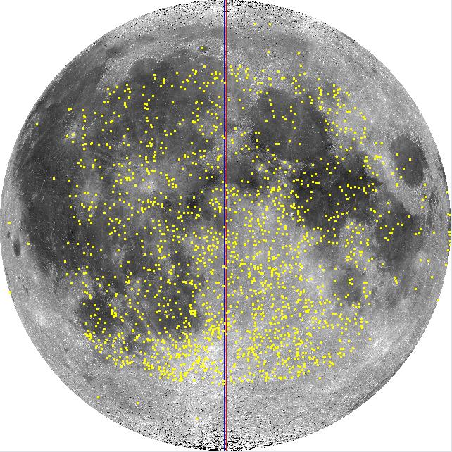
The catalog of this paper is much briefer [than Wood's full catalogue], is restricted to those craters which were included in the measures, and is quite differently arranged. The two catalogs, however, contain the same depth results, except where I have suppressed heights relating to large irregular objects. Note that the measures were restricted to those craters in which the lower end of the shadow (the tip) fell close to the center of the interior of the crater. [Arthur (1974) at 118]. As can be seen in Figure 2 (above) - a plot of the features relating to the Arthur-Wood data - Arthur (1976) limited data to a spherical square bounded the north-south 45° and east-west 45° selenographic meridians. Arthur (1974) at p. 120. Wood (1973) also estimated the heights of approximately 37 central peaks of craters. The locations of the features corresponding to these measurements are shown in Figure 3 (to the right). Arthur stated the uncertainty of measurements were plus or minus 100 meters for large complex craters and 25 to 50 meters for smaller simple craters. Arthur (1974) at 121. |
|
|
High-resolution photography from the Command Module of the last three Apollo missions - Apollos 15, 16 and 17 - launched another phase in lunar cartography. The images for the nearside roughly correspond to a "V" shaped band running between N20 and S20 lunar latitude shown in Figure 4. Stereographic photomaps were prepared from the Apollo images - the Lunar Topographic Orthophotomap (LTO) series - with an unprecedented depth accuracy stated as: "The evaluated horizontal and vertical accuracy of subject series at 90% probability generally ranges from 160-500 meters and 30-115 meters respectively . . ." Schimerman, U.S. Defense Mapping Agency (1973). Individual maps in the series may contain additional accuracy statements. The index map to the LTO charts is shown in Figure 4. A sample excerpt for a 100-meter accuracy LTO map for the Apollo 15 - Mt. Hadley landing site is shown in Figure 5. |
|
|
|
Micromaps of specific lunar features from the Apollo stereograms - the Lunar Topophotomap (TPM) series - where also prepared with a depth accuracy of 50 meters. The corresponding 50-meter accuracy map for the Apollo 15 Mt. Hadley landing site is shown in Figure 6. Pike (1976) used a combination of measurements from Arthur (1974), lunar topographic orthomaps, Lunar IV imagery and Apollo 14 through 17 panoramic picture cameras to measure numerous dimensions for 484 craters and other features on the near side Moon. The table presented here extracts 239 of Pike's crater measurements for diameter and depth, the remaining measurements being for unnamed craters, non-crater features or craters that could not easily be associated with USGS Planetary Gazetteer of Nomenclature listed features. Figure 7. |
|
25 meter accuracy - Apollo 17 radar altimeterElachi (1976) reported the results of a radar altimeter that was attached to the Apollo 17 Command Module - the Apollo Lunar Sounder Experiment (ALSE). ALSE provided a continuous 30 kilometer wide swath of altimeter readings, including profiles for large mares like Crisium, Tranquilitatis and Serenitatis. Elachi also reported high precision 25 meter accuracy crater diameters and depths for 16 craters, 10 of which could be easily matched to the U.S.G.S. Planetary Gazetteer. Most of the Elachi's smaller crater measurements cover features in Arthur (1974). Figure 7. Crater depth to crater diameter relationshipsAmong the features measured in Pike (1976) and his follow-up work in Pike (1977) (and illustrated in Figures 1 in both Pike (1976) and Pike (1977)): |
|
Table 4.1 in the Lunar Sourcebook (1991) summarizes empirical relationships found from the Apollo era data described above.
Pike (1974) found empirical relationships between crater depth and diameter based on 171 small craters less than 15km in diameter. Elachi (1976) also plotted his small crater depths to their diameters, finding that for his small sample of craters less than 30 kilometers in diameter, the ratio of the crater depth was constant at 0.2. Elachi (1976) at Figure 2. For large craters, Pike (1974) also found an empirical relationship of rim-to-rim crest to depth of about Drc^0.3. These diameter to depth relationships are summarized in the following table and Figures 8 and 9. A plot of the ratios of 1,905 crater depths to diameters compiled here and shown in Figure 8 - principally from Arthur (1974) and Pike (1976) - illustrates Elachi's small crater depth to diameter ratio. In Figures 8 and 9, the trend line is fitted to 11 of 16 of Elachi's craters. Pike's small and large crater relationships are also shown. A plot of the ratio of the crater depth to diameters - by crater diameter - for 1,905 nearside crater measurements compiled here is shown in Figure 10.
|
|
|
||||||||||||||||
|
|
|
Pike (1977), Pike did further follow-up work on the crater diameter to depth relationships based on apparent crater volumes as opposed to rim-to-rim crest diameters.
Wood and Andersson (1978) examined 2,589 fresh Copernican nearside craters in more detail. They defined morphology classes for this group of young craters into statistical archtypes represented by Albategnius C, Biot, Sosigenes, Triesnecker, and Tycho. They better defined equations statistically relating the diameters of craters in each morphological subtype to their depths and central peak heights. They reconciled differences between crater diameter to depth relationships found in their larger crater sample and in Pike's previous work based on differences between subpopulations of highland and mare craters.
Hale and Head (1979) measured the characteristics of crater diameter, rim crest height and central peak height for 90 nearside and 85 farside craters from the LTO map series for craters larger than 17 km in diameter. This was part of a continuing series of studies following up on and with Wood (1973). Like Pike before her, Hale did not publish a catalogue of crater characteristics that includes the height of the crater central peaks that they studied. They proposed equations to relate rim crest crater diameters and the crater floor width to the height of the crater's central peak. Hale and Grieve (1982) performed a similar analysis based on digitized LTO maps and the volumes, not diameters, of craters.
The empirical mathematical relationships found by Wood and Hale are all in the form of y = a * D^b - where a and b are coefficients and D is the rim to rim diameter of the crater. These empirical relationships are summarized in the following table and graph:
|
|
|
As noted above, Wood and Andersson (1978) better defined diameter to central peak height relationships for young fresh craters.
That Pike (1976) did not record central peak heights and that Hale and Head (1979) did not publish their central peak height take-offs from LTO maps creates an amateur research opportunity. Pike identified about 80 craters as having a central peak that are on LTO 100-meter accuracy maps, but for which there is no currently published 100-meter accuracy central peak height measurements. A 100-meter accuracy central peak height measurement might be recovered for these craters from the LTO maps. Details of this opportunity are discussed elsewhere.
After Wood's departure from the Lunar & Planetary Institute in 1973, Wood's work was continued on farside craters by post-directorial researcher Leif Andersson under the direction of Whitaker. The combined Wood-Arthur and Andersson-Whitaker catalogues were published in 1982 as the NASA Catalogue of Lunar Nomenclature (NCLN). However, the NCLN contained a reduced data set: only crater diameters are reported, not depths. Johnathan McDowell digitized the NCLN in 2004. Leif Andersson, who passed away shortly before the publication of the NCLN, was honored post-humously by assignment of his name to C. Andersson, a 13 kilometer diameter crater at S49.7, W95.3.
1995 saw the first publication of the USGS Gazetteer of Planetary Nomenclature by Batson and Russell. The USGS Gazetteer sought, in part for the Moon, to reconcile IAU recognized features with NCLN changes. The current online version of the USGS Gazetteer of Planetary Nomenclature is accessible over the internet.
1994 saw the Clementine multi-spectral lunar imaging mission. Clementine took multi-spectral images of the lunar surface, took photographic stereograms, and using a laser altimeter and ranging instrument (LIDAR) located absolute elevations for approximately every 512 square kilometers of the lunar surface with spacing varying between 20 and 100 kilometers depending on terrain. Clementine collected 72,548 LIDAR elevation points between 79° south and 81° north, with a vertical accuracy of 40 meters and a horizontal resolution of about 100 meters. Figure 12 shows a plot of Clementine LIDAR altimeter points from about 45 north and approaching the lunar region. Using 1,307 stereograms of the north and south poles, over three million terrain elevations were generated for the south and north polar regions not covered by LIDAR elevations at a frequency of approximately 1.2-1.3 square kilometers. The LIDAR points where combined by Rosiek (2002) with stereogram imaging of the north and south polar regions and the equatorial band in order to generate the first global lunar map showing the relative absolute elevation of broad regions of the lunar terrain with 1km per pixel resolution. Although the LIDAR altimeter points have a much higher level of accuracy at widely-spaced measuring points, once combined with stereograms into a digital elevation model, the accuracy of the final digital elevation model is reduced. Cook (2002) prepared an improved digital elevation model based on Clementine LIDAR and stereophotos. Figure 13 shows an almost luminescent Clementine digital elevation image of the whole Moon (nearside and farside) in a Mercator projection between meridians 70 north and 70 south looking to the east. The near-side mares are the depression near the center of the image, Sinus Medii is the left-to-right running highland near the image center, and the far-side South Polar Atiken Basin appears at the upper right-hand corner. Figure 14 shows the global lunar topographic map in a petal leaf layout.
|
|
|
|
This digital elevation map was combined with an air-brush terrain map of the lunar surface with 900 meter per pixel resolution in USGS Series 1-2769. USGS Series 1-2769 - three 315 Mb files - is the most detailed topographic map that can be publicly downloaded. These datasets form the core of the U.S.G.S. Map-A-Planet online application familiar to many amateur lunar observers. USGS Series 1-2769 is the map that displays as shaded-terrain relief in USGS Map-A-Planet renderings of the lunar surface.
Because the base resolution of the Clementine digital elevation model is about 900 to 1000 meters, it does not produce fine crater depth measurements that are superior to the Apollo era data discussed above.
According to Selenography Today, the leading contemporary amateur lunar study journal, Clementine visual images were taken at too high a sun angle in order to be useful for shadow depth or height measurements. Lena (2006).
For those wishing to further explore the raw orbital Clementine visual images, they are stored at the NASA Washington Univ. (St. Louis) Planetary Data Systems (PDS) Clementine Data Node. NASA-JPL provides a viewer compatible with Clementine PDS stored images for either Windows, UNIX or Mac operating systems. Arthur (1974) provides a reduction algorithm.
The Clementine photoimages, also available from U.S.G.S. Map-A-Planet, have a resolution between 100 to 325 meters and typically covered about 40 square kilometers. These images can be used to measure crater diameters. The USGS Map-A-Planet applet displays the resolution of the image at the bottom of screen in pixels per kilometer.
The following table includes data for an example image of the crater Plinius from USGS Map-A-Planet. The crater Plinius is located on the border between Mare Serenitatis and Mare Tranquilitatis. Click on the image in the following table to display a full resolution version at the image scale listed in the table.
| Item | Data |
|---|---|
| Pike (1976) data | Dia. 42.1 km; Depth. 3.07 km Lat. 15.4 Long. 23.7 |
| Large scale Plinius image |  |
| Map-A-Planet large image scale information | 1.8952 kilometers per pixel |
| Small scale Plinius image |  |
| Map-A-Planet small image scale information | 0.2369 kilometers per pixel |
Click on the image and then save the full version to your desktop. Open the jpg file with an image editor. Most paint programs display the x-y coordinate of the pixel currently under the cursor. The top of Plinius in the example image is at about pixel row 44; the bottom is at 217. A simple computation of 217-44 = 173 pixels * 0.2369 km/pixel = 40.93 kilometers. Using the square root distance formula, several diameter measurements should be made, noting the slumped wall in the southeast quadrant, and averaged. Since two points are measured on the image to define one crater diameter, the inherent uncertainty of this single measurement is twice 100-325 meters or 200 to 750 meters.
|
Another technique - best ellipsis fit - using Microsoft Paint or another drawing program like Adobe Photoshop - is illustrated in Figure 15. After Pike (1976), most craters are not perfect circles. In Figure 15, a construction is used in MS Paint to fit an ellipsis to the crater using Paint's ellipsis tool. In MS-Paint, straight horizontal and vertical lines can be drawn by using the Line Tool while depressing the SHIFT key. In Figure 15, the crater has been enscribed in a square by drawing horizontal and vertical lines lines that are tangent to the crater's rim on four sides. Then the diagonal lines were added. If the MS-Paint ellipsis tool is placed on any corner of the square and then is dragged to the opposite corner, an ellipsis will be drawn that is inscribed inside the square. Varying the starting position of the Ellipsis tool along the diagnol line will vary the size of the ellipsis. Moving the starting point to the left or right of a diagnol and corner point varies the eccentricity of the ellipsis. By experimentation, the best fitting ellipsis can be drawn over the crater and its major axis measured. Two possible plots are suggested in Figure 15. |
|
Earth-based radar mapping of the Moon began in the post-World War II era using surplus military antennae. Thompson (1979) produced a whole nearside Doppler radar map of the Moon to a resolution of 1 kilometer using the Haystack and Arecibo radio observatories.
Stacey (1997) continued and expanded this work using the Aricebo observatory by developing new Doppler radar analysis techniques that could image to a 20 meter resolution.
Since the mid-1990s, three researchers - Stacy (1997), Margot (2000) and Campbell (2004) - have pioneered the use of radar interferometry to prepare high resolution maps of lunar craters. Their efforts have been principally focused on maping possible ice deposits at the lunar poles, e.g. - Stacy (1997), Margot (2000) and Campbell (2006b). In the search for lunar ice deposits, Margot (2000) and Campbell (2005) illustrated how the technique is usually used to achieve 400 meter resolution, but can be pushed to a 150 meter horizontal and a 20 meter vertical resolution.
Margot (1999a, abstract) prepared a detailed topographic map of the crater Tycho with a horizontal resolution of 200 meters and a vertical resolution of 20 meters using Earth-based radar interferometry. Margot (1979) found that Tycho's central peak rises 2,400 meters above the mean crater floor and that the crater's depth was 4,700 m between mean rim and mean floor. Pike (1976) reports a crater depth of 4,600 meters; Wood (1973) reports a central peak height of 2,260 meters. An radar map image of Tycho can be found in Figures 5 and 6 of Margot (2000).
Margot (1999b) prepared the north and south lunar pole radar interferometer maps of the north and south lunar poles above north-south latitudes 87.5° to a horizontal resolution of 150 meters and a vertical resolution of 50 meters.
Campbell (2000) produced a 300 meter resolution radar map of Posidonius. Campbell (2004) and Campbell (2005) produced 400 meter resolution radar maps of the lunar south pole.
Campbell (2006a) acheived 20 meter resolution in mapping C. Shoemaker at the lunar south pole. Based on this increased resolution accuracy, Campbell (Oct. 2006b) concluded that it was unlikely that there were ice deposits at the south lunar pole.
Although focused on lunar ice, the north and south lunar pole digital elevation models prepared by Margot and Campbell could be used to prepare enhanced accuracy crater depth and diameter catalogues, as of this date they have not be used for that purpose.
|
Kapral and Garfinkle (2005), members of the Geologic Lunar Research Group (GLRG), published a catalogue of approximately 2,500 verified and unverified domes and other miscellaneous features. The Kapral-Garfinkle catalogue is a compliation of domes compiled from approximately 25 journal and other sources, including the Journal of the Assoc. of Lunar and Planetary Observers. Of those entries, approximately 750 involve verified and unverified domes and 186 verified and unverifed domes have associated height measurements. The distribution of those 186 domes are plotted in Figure 16. The location of the 751 domes with listed diameters are plotted in Figure 17. A digitized catalogue is provided here. This catalogue is also plotted by the GLRG on a copy of the LAC charts. The GLRG's Wöhler et al (2006) pioneered a photoclinometry technique that uses dome albedo to measure the height of lunar domes down to below a 100 meter level of precision. The stated precision is 10 percent for dome heights and 5 percent for dome diameters. Wöhler et al (2006) at Sec. 4.5. Evans (GLRG, Selenography Today #1, 2006) illustrates a version of that technique using a simple Excel spreadsheet to measure lunar dome heights. Davis's technique of using test measurements based on features on LTO and LTP maps in order to establish an accuracy baseline suggests a method by which amateurs can quantify the reliability of the technique that they use. |
|
|
The accuracy of crater depths and diameters from lunar orbital imagery during the Apollo and Clementine eras is discussed above. The current state-of-the-art of lunar topography study was described in the June 2006 issue of Selenography Today as follows:
Despite the fact that the Moon has been visited by six manned missions and a multitude of unmanned spacecraft, its surface is far from being completely explored. . . . The Clementine image data, however, are largely unsuitable for photogeologic and topographic analyses due to the low phase angles and high illumination angles at which most of them were acquired. Hence, the best available set of spacecraft images globally covering the lunar surface, taken under low to moderate illumination angles and thus revealing the relief of the lunar surface, is still that obtained during the Lunar Orbiter programme in the mid-1960s. The ongoing Smart 1 mission, which is intended to be terminated by a spectacular crash of the spacecraft on the lunar surface at the end of September 2006, will provide the first high-resolution set of orbital lunar images acquired with modern sensory devices primarily at oblique illumination. [Lena (2006).]
How accurate can amateurs measure crater depths and feature heights from the Earth? Has amateur astrophotography progressed to the point in the last three years, where reasonably accurate height and depth measurements from shadows in astrophotographs can be made that compete with Earth based micrometer measuring? More recently advanced amateurs like Paolo Lazzarotti regularly make lunar images with linear resolutions down to 0.11-0.22 arcsecs per pixel that correspond to sub-kilometer linear distances. For a lunar feature at N0, E0 when the Moon is at 384,440 kilometers distant, 0.11 arcsecs corresponds to about 200 meters.
There are competing parameters that affect the resolution of modern convoluted astrophotographs. At low oblique sun angles, the shadow cast by feature will be longer than 200 meters even though the feature is less than 200 meters in height or depth. Conversely, modern high-resolution astrophotographs are convolutions of many images taken over time, sometimes several minutes. At the equator, the terminator moves across the lunar disk at about 510 meters a minute. At 45 degrees north latitude, it moves at about 360 meters a minute.
Amateur Bill Davis in the November 1998 issue of Sky & Telescope described how he tested the accuracy of his use of a microfilament to measure the height of features on the Moon. Davis called John Westfall who suggested the following process: Use the Lunar Topographic Orthophotomaps (LTO) as a baseline. They have an accuracy of 100 meter contour intervals. From microfilament 119 measurements, Davis found he could estimate heights to within a 10% accuracy of the LTO map value for Mt. Harbinger and 18 other lunar mountains. Davis commented that the best measurements were made with a solar angle between 3 and 6 degrees.
Geologic Lunar Research Group members Wöhler et al (2007) described a topographic study of Rupes Bürg applying shadow techniques to advanced modern astrophotographs of the Moon. Wöhler et al (2007) estimated the height of Rupes Bürg at approximately 400 meters.
Wöhler et al (2007) also demonstrates how light profile curve tools, a feature of many common astrophotography software packages, can be used to characterize the topographic profile of lunar ridges.
Jim Mosher's and Henrik Bondo's Lunar Terminator Visualization Tool (LTVT) lunar planetarium software can relieve the amateur of much of the reduction burden. It includes a shadow measuring tool and is based on a high-accuracy lunar ephemeris. LTVT is still in the post-beta revision, development and refinement stage. The accuracy of measurements made using its measuring tool has not been fully tested. Initial ancedotal testing indicates that a crater depth accuracy between 5-10% compared to LTO map depths can be achieved with careful technique, including checking image alignment to 1994 UCLN control points. Pilz in Wood, LPOD 12/24/2006; Mosher, personal communication (12/2006).
Jim Mosher's and Henrik Bondo's Lunar Terminator Visualization Tool (LTVT) lunar planetarium software can be used to plot any feature list provided here over the top of a user's astrophotograph of the Moon. (The feature characteristic tables presented here have also been forwarded to the authors of Virtual Moon Atlas and may be included in VMA as they feel is appropriate.) The following table links to LTVT feature name files that will plot the various feature depth lists compiled into lists here:
| Description | Download | Version date |
|---|---|---|
| All Apollo era depth-height lists | Link | 12/23/2006 |
| Crater depths - Arthur (1974) | Link | 12/23/2006 |
| Crater depths - Pike (1976) and Elachi (1976) | Link | 12/23/2006 |
| Central peak heights - Wood (1973) and Margot (1999a) | Link | 12/23/2006 |
| Right-click to download files. |
| Description | Download | Version date | Distribution |
|---|---|---|---|
| Kapral & Garfinkle (2005) lunar dome diameters (N~750) verified and unverified domes | Link | 12/26/2006 | Figure 16, above |
| Kapral & Garfinkle (2005) lunar dome heights (N=186) verified and unverified domes | Link | 12/26/2006 | Figure 17 |
| Westfall (2000) depths for larger named craters | Link | 12/26/2006 |  |
| Cherrington (1969) Low-accuracy feature depths and heights for larger named craters | Link | 12/23/2006 |  |
| Cherrington (1969) Low-accuracy central peak heights | Link | 12/23/2006 |  |
| Ring dike craters (N=243) from Cameron (1974) | Link | 12/26/2006 |  |
| Bright ray craters from ALPO 2006 bright ray crater list and Elger (1895) (N=286) | Link | 12/26/2006 |  |
| Dark-Haloed Craters from ALPO 1976 DHC list (N=83) | Link | 1/7/2007 |  |
| Right-click to download files. |
When using this csv files with LTVT, the following options must be set in order to plot the feature lists:
The shadow length measuring tool and user image calibration routine are described in depth in the LTVT help guides. The shadow length measuring tool is used to measure crater depths and feature heights from user astrophotographs. Beginning with LTVT version 16.0 (12/24/2006), Lunar Topographic Orthophotomaps (LTO) with 100 meter accuracy (that cover only part of the nearside Moon) can be directly imported into LTVT. This allows users to easily check the accuracy of their depth measurements.
Features in the LTVT dot-name lists provided here are coded with the following informal schema:
| USGS PGN Object Type | LTVTObjectCode | LTVT Object Code Description |
|---|---|---|
| Crater, craters | CD | Crater depth |
| Dome-Verified | PH | Positive feaure height |
| Dome-Unverified | PH | Positive feaure height |
| Dome-Verified | DD | Dome diameter |
| Dome-Unverified | DD | Dome diameter |
| Dorsum, dorsa | DH | Dorsum height |
| Lacus | LD | Lacus depth |
| Mare, maria | PH | Positive feaure height |
| Misc feature | PH | Positive feaure height |
| Mons, montes | PH | Positive feaure height |
| Palus, paludes | PD | Palus depth |
| Promontorium, promontoria | PH | Positive feaure height |
| Rima, rimae | RD | Rima depth |
| Rupes | RH | Rupes height |
| Satellite Feature | CD | Crater depth |
| Scarp | RH | Rupes height |
| Sinus | PD | Palus depth |
| Vallis, valles | VD | Valley depth |
In addition to the distance measuring features of LTVT and using USGS Map-A-Planet, discussed above, a distance measuring tool can be found in Christian Legrand's and Patrick Chevalley's Virtual Moon Atlas (VMA) software. VMA Pro version 3.5, released in November 2006, includes a lunar database called Datlun. This database includes both crater diameter and depth data, principally for named craters but not satellite features, from a number of sources including Viscardy (1985) (Earth based telescope measurements), the International Astronomical Union and other journal literature. Legrand, 12/2006 personal communication; Datalun help file.
LTVT can also be used to plot features compiled here onto amateur's own lunar images and includes a measuring tool discussed above.
A table of craters and satellite feature names, positions and diameters was prepared from the online USGS Gazetteer of Planetary Nomenclature. Pike (1976) was reviewed. Where Pike's measurement corresponded to (1) the Gazetteer feature name and (2) the crater diameter was within 3 kilometers of the Gazetteer measurement, Pike's crater diameter, depth and peak height were digitized. Arthur (1974) was reviewed. Where Arthur's measurement corresponded to (1) the Gazetteer feature name and (2) the crater diameter was within 5 kilometers of the Gazetteer measurement, Arthur's crater diameter was digitized. About 20 miscellaneous Pike and Arthur features over 20 kilometers in diameter or length were added. This resulted in a table containing the USGS Gazetteer lunar feature name, position, NCLN crater diameter, and the crater depths from these two sources.
The difference between the NCLN crater diameter and the Arthur and Pike diameters was computed in order to verify the association based on feature name and size. (It was not possible to review the original photos and maps to correlate the Gazetteer, Arthur and Pike data.) Generally, entries were the diameter or length differences exceeded one kilometer were excluded. Entries above those criteria were reviewed on an individual basis. Some large craters were the diameter differences exceeded 1 kilometer were included on a judgment basis. The following table summarizes the diameter differences between the Gazetteer diameter or feature length and the sources' diameter or length. 72% differ by less than one-quarter of a kilometer.
| Difference km | Count |
|---|---|
| 0.25 | 1375 |
| 0.5 | 318 |
| 0.75 | 84 |
| 1 | 36 |
| More | 83 |
| Total | 1896 |
Based on the above, it was felt that the association between the Gazetteer name and position entries and the source data was valid.
Total crater depth data digitized from Arthur (1974) and Pike (1976) is summarized as follows. Note 100 percent of each catalogue was not digitized, as also listed in the following table. Only those entries that could be unambiguously associated with a USGS Gazetteer of Planetary Nomenclature were included:
| Type | Count Arthur (1974) | Count Pike (1976) | Count Total Extracted |
|---|---|---|---|
| Crater, craters | 118 | 162 | 280 |
| Mare, maria | 3 | 3 | |
| Satellite Feature | 1539 | 74 | 1613 |
| Count Total Extracted | 1657 | 239 | 1896 |
| Count Total in Source | 1900 | 484 | 2384 |
For Elachi (1976), 10 out of 16 reported depth measurements could be associated with USGS PGN crater names and are incorporated here. Margot (1999a) Tycho crater depth and central peak height were included.
A sort order code field was added that contains a subjective ordering of source catalogues by accuracy. This facilitates printing of compiled, multi-catalogue lists so the assumed highest accuracy measurement for a single feature is displayed first.
The resulting table was prepared in Microsoft Excel and exported to HTML for internet distribution for the benefit of the amateur lunar enthusiast community. LTVT plotting files were created so amateurs could plot features listed here on their own lunar images.
This retrospective on the gathering of higher accuracy lunar crater and feature depth, height and diameter measurements represents one of many of the high-points of the Apollo era explorations. It represented a great-leap forward in our understanding of lunar topography. That effort continued through Clementine (1994) and Earth-based radar interferometry (1997-2006) and will continue in future explorations.
There is a cautionary lesson-learned in this history. Some measurements from the Apollo era have been lost.
Hopefully, the future will chart a diligent path towards perserving raw measurements and preventing the loss of hard won lunar data, purchased through public financing. The current NASA-USGS PDS system - with its policy of open internet data distribution of publicly-funded science results - is one of the best examples of cooperative science data sharing. At the 57th Annual International Astronautical Congress, NASA Chief Administrator Griffin asked that "lunar science data should be openly shared among the science community, just as we do with other planetary science data." Griffin (2006) at 11. Griffin suggested the collective sharing and standardized formatting of all data from upcoming lunar missions. Ellison (2006).
This note is amateur astronomer work product. Corrections to any errors are welcomed and appreciated.
Andersson, Leif E. & Whitaker, E.A. 1982. NASA Catalogue of Lunar Nomenclature (NCLN). NASA Reference Publication 1097. (Online version by J. McDowell 2004-2006)
Arthur, D. W. G. Sept. 1974. Lunar crater depths from Orbiter IV long-focus photographs. Icarus. 23:116-133.
Bussey, B. and Spudis, P.D. 2004. The Clementine Atlas of the Moon. - U.S.G.S. Map-A-Planet Online applet
Campbell, B. A., Campbell, D. B., Nolan, M. Mar. 2003. New High-Resolution 70-cm Wavelength Radar Images of the Moon. 34th Annual Lunar and Planetary Science Conference, March 17-21, 2003, League City, Texas, abstract no.1700. 2003LPI....34.1700C
Campbell, B. A., Campbell, D. B., Hawke, B. R., Lucey, P. G. Mar. 2004. Radar Properties of Lunar Basin Deposits. 35th Lunar and Planetary Science Conference, March 15-19, 2004, League City, Texas, abstract no.1659. 2004LPI....35.1659C
Campbell, B. A., Campbell, D. B., Chandler, J. Mar. 2005. New 70-cm Radar Mapping of the Moon. 36th Annual Lunar and Planetary Science Conference, March 14-18, 2005, in League City, Texas, abstract no.1385. 2005LPI....36.1385C
Campbell, D.B., Carter, L.M. 2006a. Earth Based Radar Imagery and Topography: Input to LCross Target Selection. _______.
Campbell, D.B., Campbell, B.A., Carter, L.M., Margot, J.L., Stacy, N.J.S. Oct. 2006b. Nature. 443(7113):835-837. 2006Natur.443..835C
Cherrington, Ernest H. (1969) (2 ed 1984). Exploring the Moon Through Binoculars and Small Telescopes. Dover. ISBN: 0486244911
Chevalley, Patrick and Legrand, Christian. 2006. Virtual Moon Atlas. (Software)
Cook, A. C., Spudis, P. D., et al. 2002. Lunar Topography and Basins Mapped Using a Clementine Stereo Digital Elevation Model. 33rd Annual Lunar and Planetary Science Conference, March 11-15, 2002. 2002LPI....33.1281C
Davis, Bill. Nov. 1998. The Mountains of the Moon. S&T 96(5):114
Elachi, C., Kobrick, M., Roth, L. et al. 1976. Local lunar topography from the Apollo 17 ALSE radar imagery and altimetry. 1976Moon...15..119E
Ellison, Doug. Oct. 2, 2006. The Big Guns. (Web blog by attendee of 57th Annual International Astronautical Congress).
Evans, Richards (Geological Lunar Research Group). June 2006. The Moon on a Spreadsheet: Photoclinometry using Excel. Selenography Today. 1:21-59
Griffin, M. (NASA). Oct. 3, 2006. Administrator's Remarks Before the 57th Annual International Astronautical Congress.
Hale, W.; Head, J. W. 3/1979. Central Peaks in Lunar Craters: Morphology and Morphometry. LUNAR AND PLANETARY SCIENCE X, P. 491-493. Abstract.
Hale, W. S.; Grieve, R. A. F. 1982. Central Peak and Peak Ring Development: Constraints from Lunar Peak Volumes. LUNAR AND PLANETARY SCIENCE XIII, P. 297-298. Abstract. 1982LPI....13..297H
Heiken, Grant H. et al (eds). 1991. Lunar Sourcebook: A User's Guide to the Moon. Cambridge Univ. Press. (Out-of-Print publication web distributed by LPI)
Kapral, C.A., Garfinkle, R. A. August 2005a. GLR Lunar Domes Catalog.
Kapral, C.A., Garfinkle, R. A. August 2005b. GLR Lunar Domes Catalog. The Lunar Observer.
Kuiper, G. (ed.), Arthur, D.W.G., Moore, E., Tapscott, J.W. and Whitaker, E.A. 1960. Photographic Lunar Atlas. Univ. of Chicago Press.
Kuiper, G. (ed.) et al, 1960. Orthographic Atlas of the Moon. Univ. of Arizona Press.
Lena, Raffello. June 2006. Editorial. Selenography Today. 1:3-4
Lunar Planetary Institute (archivist) - NASA. 1973-1979. Lunar Topographic Orthophotomap (LTO) series
Lunar Planetary Institute (archivist) - NASA. 197_. Lunar Topophotomap (TPM) series
Margot, J. L., Campbell, D. B., Jurgens, R. F., Slade, M. A., Stacy, N. J. Mar. 1998. The Topography of the Lunar Polar Regions from Earth-based Radar Interferometry. 29th Annual Lunar and Planetary Science Conference, March 16-20, 1998, Houston, TX, abstract no. 1845. 1998LPI....29.1845M
Margot, J.L., Campbell, D.B., et al. 1999a. The topography of Tycho Crater. (Abstract). J. Geo. Res. 104(E5):11875-11882. 1999JGR...10411875M
Margot, J. L., Campbell, D. B., Jurgens, R. F., Slade, M. A. 1999b. Topography of the lunar poles from radar interferometry: A survey of cold trap locations. Science. 284(5420):1658-1660. 1999Sci...284.1658M
Margot, J.L., Campbell, D.B., Jurgens, R.F., Slade, M.A. Mar. 2000. Digital Elevation Models of the Moon from Earth-Based Radar Interferometry. IEEE Trans. on Geoscience and Remote Sensing. 38(2):1122-1133
Mosher, Jim and Bondo, Henrik. 2006. Lunar Terminator Visualization Tool (LTVT) (software)
NASA-JPL. 2006. Planetary Data Systems Viewer Software Download Webpage (For NASAViewer software for Windows, Unix or Mac).
NASA and Washington Univ. (St. Louis). 2006. Clementine Gravity and Topography Data Archive. Planetary Data Service Geosciences Node.
NASA and Washington Univ. (St. Louis). 2006. PDS Clementine Data Node.
NASA and Washington Univ. (St. Louis). PDS Imaging Node. (Root leading to Clementine visual images - Unix and Max software only)
NASA and Washington Univ. (St. Louis). PDS Imaging Node. Resources node. (Unix and Max software only to view Clementine images)
NASA and Washington Univ. (St. Louis). 2006. PDS Clementine Visual Image Archive.
NSSDC. 2006. Lunar Digital Image Model, Global Sinusoidal Projection on Magnetic Tape. NSSDC Database PSPG-0070. Other id. SL-21D.
NSSDC. 1994. Clementine Topography Data Archive on CD-WO (PDS). NSSDC Database Id. PSPG-00630. Other Id. 94-004A-0A.
Pike, R. J. Nov. 1974. Depth/diameter relations of fresh lunar craters - Revision from spacecraft data. Geo. Res. Ltrs. 1974(1):291-294 1974GeoRL...1..291P
Pike, R. J. June-July 1976. Crater dimensions from Apollo data and supplemental sources. The Moon. 15:463-477.
Pike, R. J. 1977. Apparent depth/apparent diameter relation for lunar craters. Lunar Sci. Conf., VIII, March 14-18, 1977, Proceedings. (Vol. 3) 1977LPSC....8.3427P
Rosiek, M. R., Kirk, R., and Howington-Kraus, E. 2002. Color-coded Topography and Shaded Relief Maps of the Lunar Hemispheres. 33rd Annual Lunar and Planetary Science Conference, March 11-15, 2002. 2002LPI....33.1792R
Rükl, A. 2004 (2ed). Atlas of the Moon. Sky Publishing.
Schimerman, L., U.S. Defense Mapping Agency. 1973. The Lunar Cartographic Dossier. NASA Pub. NASA-CR 1464000.
St. Clair, J. H., Carder, R. W., Schimerman, L. A. Apr. 1979. United States lunar mapping - A basis for and result of project Apollo. Moon and the Planets 20:127-148. 1979M&P....20..127S
Stacy, N. J. S., Campbell, D. B., Ford, P. G. 1997. Arecibo radar mapping of the lunar poles: A search for ice deposits. Science. 276:1527-1530. 1997Sci...276.1527S
Thompson, T. W. Apr. 1979. A review of earth-based radar mapping of the moon. Moon and the Planets. 20:179-198. 1979M&P....20..179T
U.S. Air Force. 196_. Lunar Aeronautical Charts. (LAC).
USGS-NASA. 197_. A Geologic Atlas of the Moon. (Out-of-print geologic maps web redistributed by the Lunar Planetary Institute)
USGS-NASA. 6/14/2002. Lunar Clementine Globe (Petal Leaf Map). USGS-NASA. 6/2002. Color-Coded Topography and Shaded Relief Map of the Lunar Near Side and Far Side Hemispheres - Geologic Investigations Series I-2769. USGS. 2006. The Clementine Mission. (Website) USGS. 2005. Gazetteer of Planetary Nomenclature. (Online version) USGS. 2006. Map-A-Planet - Clementine 790nm Baseline Images - Online Web Applet [USGS] Batson, Raymond M. & Russell, Joel F. 1995. Gazetteer of Planetary Nomenclature. U.S. Geological Survey Bulletin 2129. Washington: U.S. Government Printing Office. Viscardy, Georges. 1985. Atlas-guide photographique de la lune: ouvrage de référence ŕ haute résolution. Masson. ISBN/ISSN/EAN : 2-225-81090-7 Westfall, John E. 2000. Atlas of the Lunar Terminator. Cambridge Univ. Press. Whitaker, E.A., Kuiper, G.P., Hartman, W.K. and Spradley, L.H. 1963. Rectified Lunar Atlas. Univ. of Arizona Press.
Wöhler, C., Lena, R. , Lazzarotti, P. , Phillips, J. , Wirths, M. , Pujic, Z. Aug. 2006. A combined spectrophotometric and morphometric study of the lunar mare dome fields near Cauchy, Arago, Hortensius, and Milichius. Icarus. 183(2):237-264 2006Icar..183..237G Wöhler, Christian et al. Jan. 2007. Vertical Studies about Rupes Bürg. Selenography Today. 3:65-78 Wood, Charles A. Moon. 1973. Central Peak Heights and Crater Origins. 1973Icar...20..503W Wood, C.A. et al. 1974. Lunar crater statistics—Earth face. (unpublished) Wood, C.A. and Andersson, L. 1978. New Morphometric Data for Fresh Lunar Craters. 1978LPSC....9.3669W Wood, C.A. May 13, 2004. A New/Old Catalog of Lunar Craters. Lunar Picture of the Day (LPOD) Wood, C.A. Jun. 8, 2006. Ring the Bell. LPOD. (Lazzarotti, Paolo R. and Olivetti, Tiziano image with 0.11 arcsec resolution) Wood, C.A. Sept. 25, 2006. The Sad State of Lunar Reference Material. Lunar Picture of the Day (LPOD) Wood, C.A. Dec. 2006. Personal communication. Wood, C.A. (Bob Pilz) Dec. 24, 2006. Measuring a Serpent. Lunar Picture of the Day (LPOD) No copyright is claimed as to any original materials on this web document. All original content by this author is released to the public domain. This website makes use of external content links that may be subject to copyright protection. No claim to copyright is made as to these linked external sources or any other external linked reference source. Prepared by K. Fisher fisherka@csolutions.net Org. 12/3/2006 Rev. 6/19/2007Revisions
Content-Child Safe Ratings

Site tracking
Copyright


