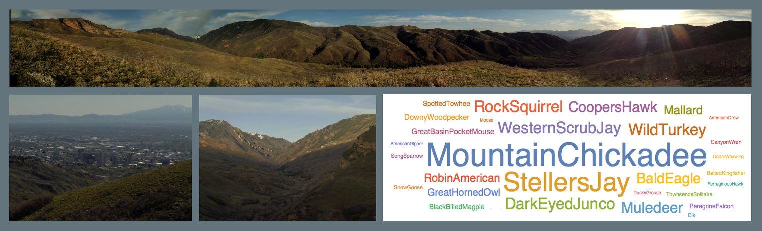
''Knowing Salt Lake City means knowing its canyons, too, for no city of my acquaintance . . . breaks off so naturally and easily into fine free country. ... Up in the Wasatch is another world, ...'' Pulitzer Prize winning author and naturalist Wallace Stegner, ‘The Sound of Mountain Water’ (1980). City Creek Canyon, shown above in the upper and lower center panels, illustrates relationships between plate tectonics, local geology, natural resources, urbanization, wildlife, and recreation. Crustal spreading beginning at the Pacific Plate in California created the Great Basin region. The Great Basin is a series of grabens and horsts bounded by parallel normal faults, and the faults raise north-south mountain ranges that begin in Nevada and end at Utah’s Wasatch Mountains and Salt Lake’s City Creek Canyon. Those mountains capture rainfall and allow large cities like Salt Lake to exist (lower left panel) in this otherwise arid state. Eight mile long City Creek Canyon begins at high-rise office towers of downtown Salt Lake City, but the canyon abruptly transitions into a natural area that provides water, recreation, and a refuge for native species. Between New Years Eve and the first week of May 2015, this author logged 700 encounters with 29 native species of birds and mammals. The lower-right hand panel is a world cloud that shows the relative number sightings of each species - all within a few minutes driving time of major city’s core.
Camera Data: Polaroid iF045, f/2.8, ISO 200, 1/250 sec.
Location: City Creek Canyon, Salt Lake City, Utah, on March 28, 2015 at 40.824201, -111.850067
Map: 40.824201, -111.850067
https://www.google.com/maps/place/@40.824201,-111.850067,14329m
Cornell Univ. Ornithology Lab., eBird (2015). Chart Species abundance for area ''City Creek Canyon - above Bonneville Blvd.''
http://ebird.org/
Earth Observatory. (Sept. 9, 2010). Basin and Range Province.
http://earthobservatory.nasa.gov/IOTD/view.php?id=46194
Earth Observatory. (Sept. 9, 2010). Basin and Range Province.
http://earthobservatory.nasa.gov/IOTD/view.php?id=46194
EPOD. (Feb. 8, 2002). Salt Lake City.
http://epod.usra.edu/blog/2002/02/salt-lake-city.html
EPOD. (May 29, 2010). The Wasatch Mountains and Salt Lake Valley.
http://epod.usra.edu/blog/2010/05/the-wasatch-mountains-and-salt-lake-valley.html
EPOD. (Jan. 2, 2001). Fault Block Mountains.
http://epod.usra.edu/blog/2001/01/fault-block-mountains.html
Wallace Stegener (1980) "At Home in the Fields of the Lord" in ‘The Sound of Mountain Water’. Univ. of Neb. Press, p. 165.
There were two events not included in the above narrative and species abundance chart that are worth noting.
First, there were 35 sightings not included in the word cloud, and they concern ''unidentified birds of prey'' seen during February and March. Those sightings principally concern bald eagles that migrate through City Creek and Salt Lake City during January, but the birds of prey are too distant to make an accurate visual identification even with binoculars. These flocks of 2-5 eagles use the pressure waves off of the northern City Creek ridge to gain altitude and then glide over City Creek to the city. In past years during those months, these migratory flocks of up to ten birds appear over the Avenues neighborhood of Salt Lake City.
Second, on the first few days of warm weather in March around noon, there is a spring explosion of insects and butterflys. This year between March 10 and March 20, butterfly densities reached 10 per mile, and on March 13, box elder bugs reached 3,000 per mile. By the beginning of April, butterfly counts reduce to their summer levels of 1 or 2 per mile. If you live in Salt Lake City, it is worth marking your 2016 spring calendar to take a break and stroll up the first canyon mile to see this event.