Summary and Purpose
Edward Emerson Barnard's 1927 classic A Photographic Atlas of Selected Regions of the Milky Way ("Barnard's Atlas") remains an invaluable resource to amateur astronomers in studying dark nebula. The online publication of the Atlas by Georgia Institute of Technology ("GIT") has made Barnard's original plates and Mary Calvert's line drawing charts of the dark clouds accessible across the world. This increases amateur astronomer opportunities to study these illusive "negative space" objects. As an aid in using Plates and Charts 1-50 (omitting Plates 27 and 51) in the Atlas, a series of Cartes du Ciel plots in J2000 coordinates of the 1875 epoch plates have been developed. Barnard's Atlas features pictures taken with the 1910's state-of-the-art 10" Bruce Telescope. The Atlas was intended to introduce the public to beauty of the Milky Way and to publish a final version of Barnard's catalogue of dark clouds.
It is hoped that these index charts to the plates and charts in Barnard's Atlas will increase the enjoyment of amateurs discovering this overlooked class of difficult objects. A common problem encountered when first observing dark nebulae is "Are you looking at the right object?" For dark objects, this questions is more vexing than when looking at typical light-emitting objects. Dark objects have even less contrast than against the background night sky than dim stars. Barnard (1919) cautioned that "It would be unwise to assume that the dark places shown on photographs of the sky are due to intervening opaque masses between us and the stars." I have always had difficulty in understanding exactly what each Barnard objects consists, given only commonly available coordinates and Barnard's tabular notes by object number.
Calvert's line drawings represent the definitive statement of the boundaries that Barnard intended for each dark cloud in his catalogue. Calvert's line drawings annotate the boundaries of distinct (solid line) and indistinct (dotted line) dark nebulae and reflective regions ("nebulosity" in Barnard's Atlas). The following excerpt from Chart 42 illustrates the three types of plotted lines -
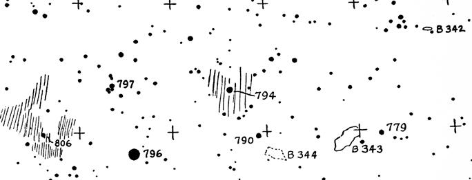
Figure 1 - Calvert line drawing excerpt showing distinct and indistinct cloud boundaries
Calvert's line charts give much more descriptive information on the catalogue object than Barnard's catalogue. A typical note to Barnard's catalogue provides little useful content, as illustrated by the note to Barnard Object No. 3: "Irregular, dark space in nebula; curved, bright strip of nebulosity in SW." Other chart alternatives, like Sky 2000 and Uranometria 2000, chart the Barnard objects, but often combine outlines of several objects into one boundary.
Calvert's line drawing charts (now distributed over the internet by the Georgia Technical Institute) present the definitive statement on what Barnard intended the boundaries of each object to be. But even Calvert's charts can be difficult to use. It is hoped that the index charts and Cartes du Ciel compatible external nebula databases will remove some of these barriers to identifying the Barnard clouds and will allow more amateurs to enjoy this interesting class of night sky objects.
External link to sample Calvert Line Drawing for Plate No. 23 near 58 Ophiuchi at the GIT.
But how does one quickly orient Calvert's line chart or Barnard's photograph for Plate No. 23 to the sky? The answer is the index charts presented here.
Download sky charts showing boundaries of Barnard's plates in J2000 coordinates
The index charts to the plates in Barnard's Atlas can be downloaded as follows. The numbers in parentheses list the Barnard Atlas plates plotted on the index chart:
East Sgr (23-26) and East Sco (12-18) Groups to mag 7.1 and 7.6
West Sgr (28-33) and West Sco (19-22) Groups to mag 7.1 and 7.6
Aql-Sct (34-41) Group to mag 7.1 and 7.6
Cyg-Cep (43-50) Group to mag 7.1 and 7.6
Per-Cas (1-2) Group to mag 7.6
Per-Aur-Ori (3-9) Group to mag 7.1 and 7.6
CMa (10) Group to mag 8.5
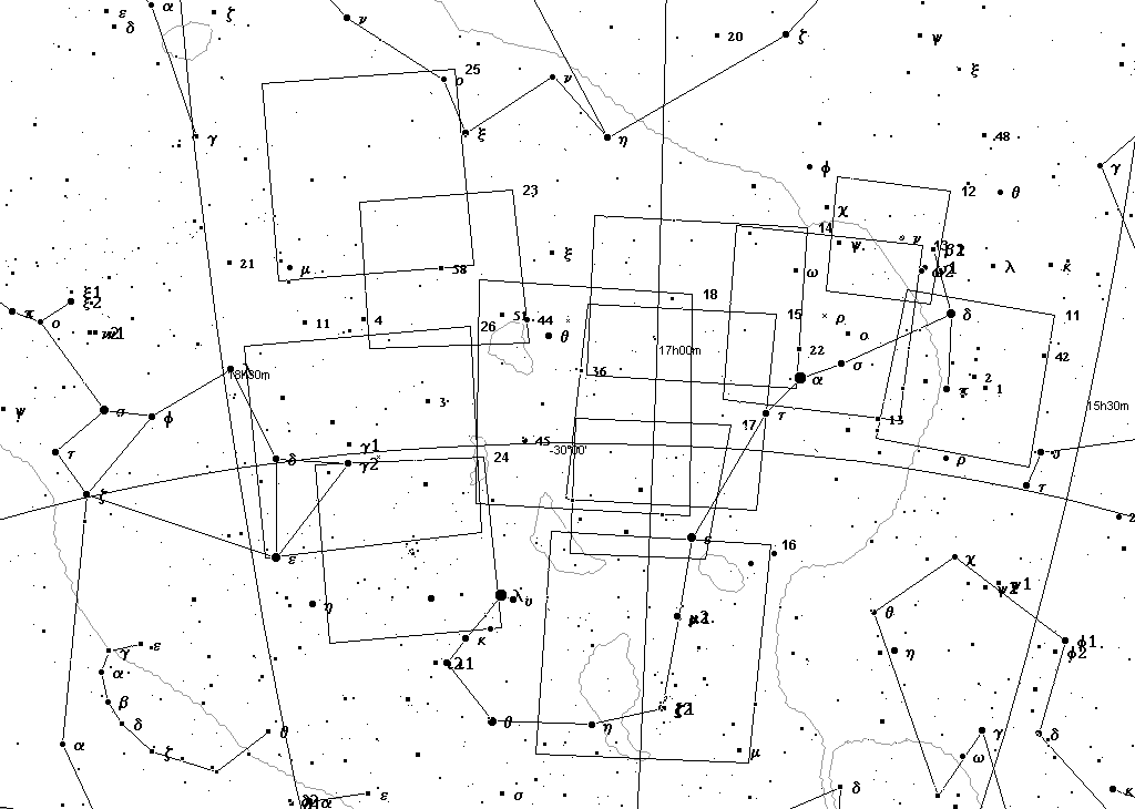
Figure 2 - East Sgr and East Sco to mag 7.1 |
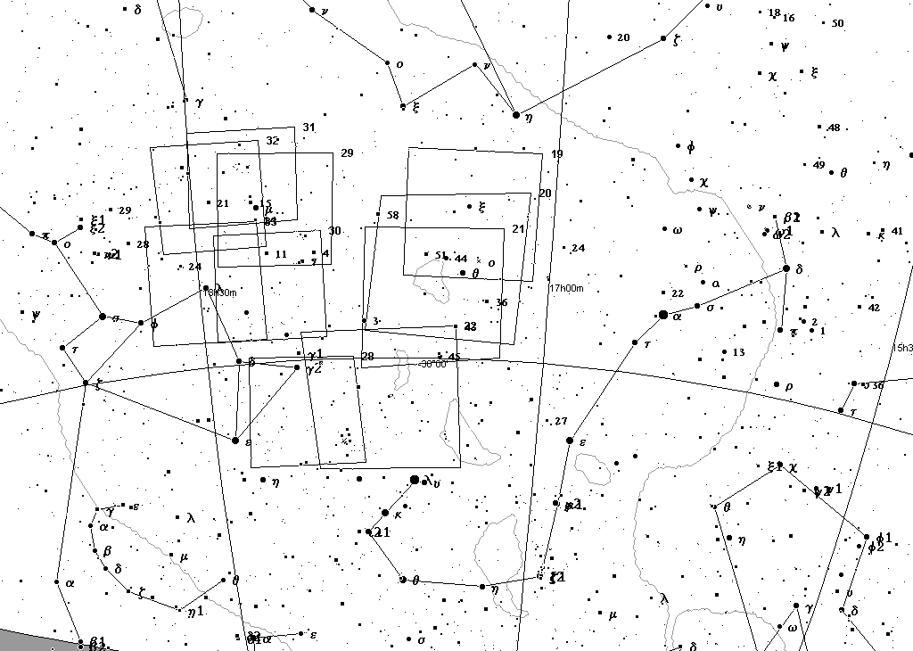
Figure 3 - East Sgr and East Sco to mag 7.6 |
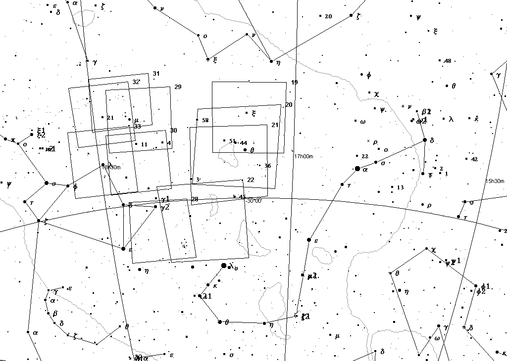
Figure 4 - West Sgr and West Sco to mag 7.1 |
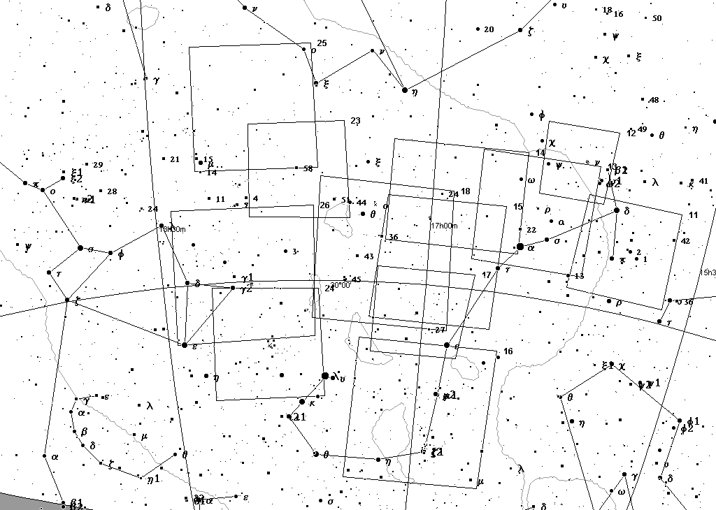
Figure 5 - West Sgr and West Sco to mag 7.6 |
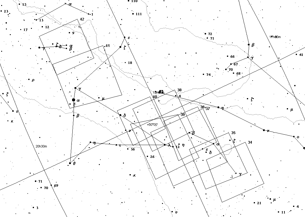
Figure 6 - Aql-Sct to mag 7.1 |
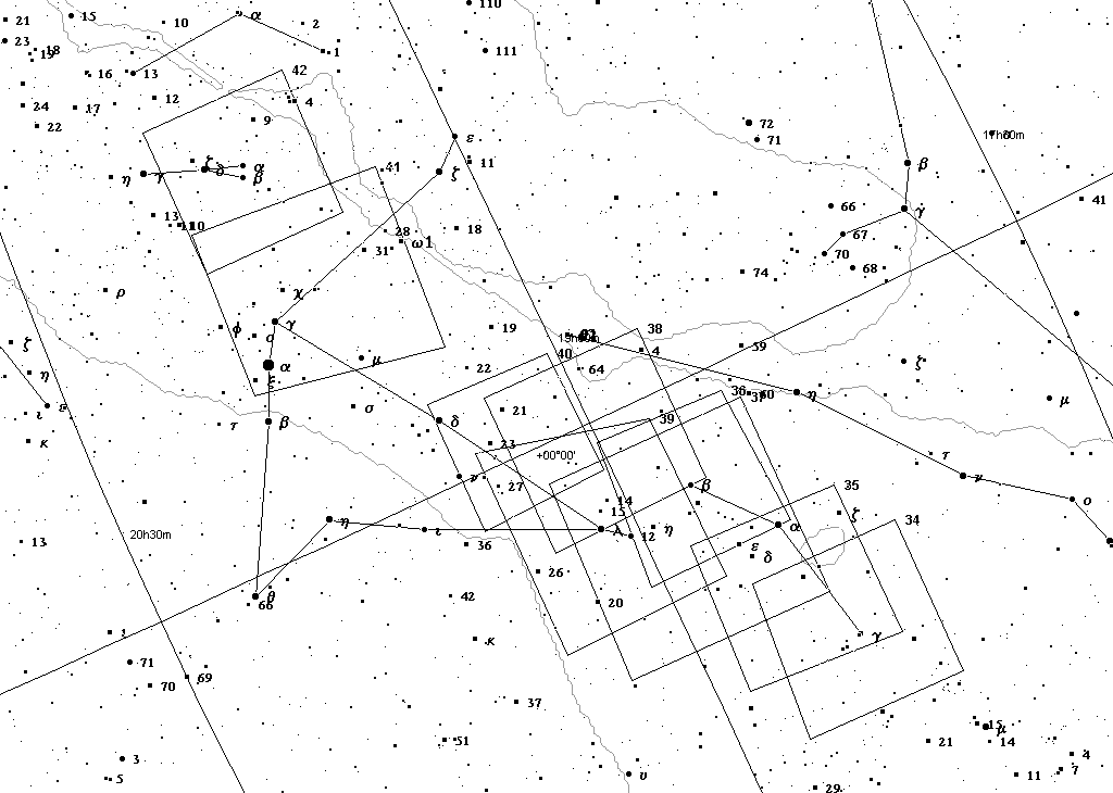
Figure 7 - Aql-Sct Group to mag 7.6 |
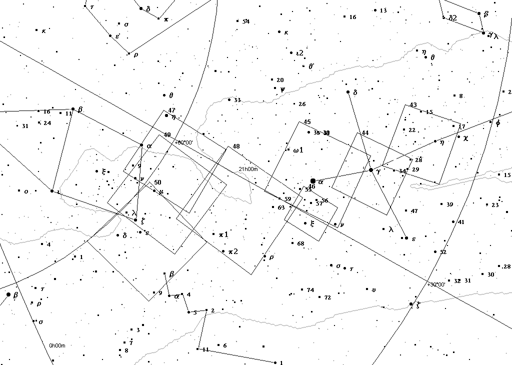
Figure 8 - Cyg-Cep Group to mag 7.1 |
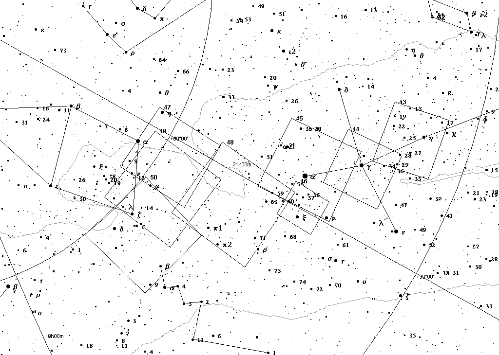
Figure 9 - Cyg-Cep Group to mag 7.6 |
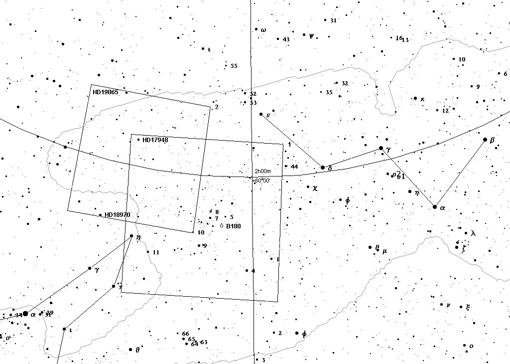
Figure 10 - Per-Cas Group to mag 7.6 |
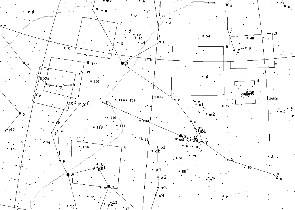
Figure 11 - Per-Aur-Ori Group to mag 7.1 |
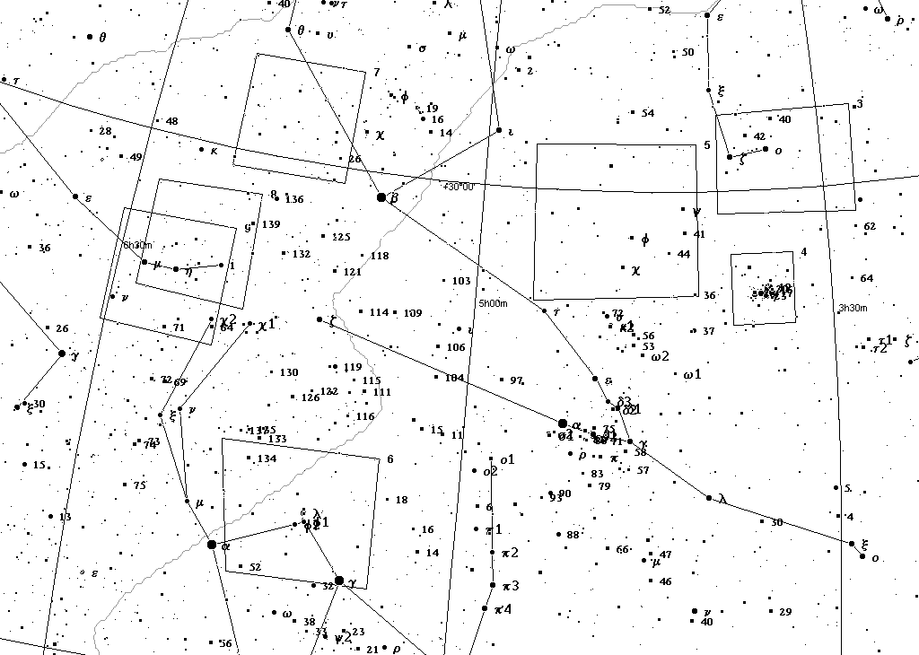
Figure 12 - Per-Aur-Ori Group to mag 7.6 |
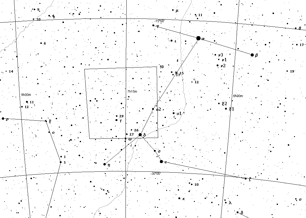
Figure 13 - CMa Group to mag 8.5 |
About the index charts to the 50 plates of Barnard's dark cloud atlas
These index charts plot the epoch J2000 boundaries of the epoch B1875 photographs in Volume I and in the annotated charts in Volume II of Barnard's Atlas. For example, the reader can use the following index chart for the Aquila area -

Figure 14 - Chart showing boundaries of Barnard's Charts in the Aquila region
- to orient Plates 34 through 42 to the night sky.
The GIT distribution of Barnard's Atlas offers PDF downloads that compile in one file for each plate:
- Barnard's photograph from Volume I of the Atlas.
- Barnard's narrative on the plate.
- Mary R. Calvert's annotated line-drawing chart showing the outlines of the objects in Barnard's catalogue from Volume II of the Atlas.
- A digital overlay of Calvert's annotated chart over Barnard's photograph.
Download the Cartes du Ciel plot of Barnard's plates in J2000 coordinates
The J2000 Barnard plate boundaries are also distributed here in three parts as Cartes du Ciel external nebula catalogues. Click to download compressed Ciel catalogue that plots the boundaries of Barnard's plates.
The Cartes du Ciel compatible nebula catalogues divide the 50 plates into three groups:
- All plates outside of the Sagittarius-Scorpius region (files bdc1.hdr, *.dat and *.txt).
- The west groups of the Sagittarius-Scorpius region (files bdc2.hdr, *.dat and *.txt). See Figure 2, above.
- The east groups of the Sagittarius-Scorpius region (files bdc3.hdr, *.dat and *.txt). See Figure 4, above.
The reason for dividing the Sagittarius-Scorpius region into two parts is that there are so many overlapping plates covering this region. Including them in one plot catalogue generates a confusing, difficult to interpret display. E.g. -
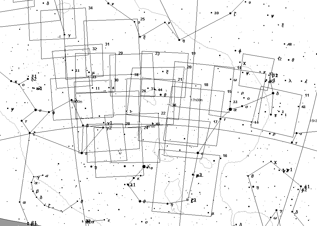
Figure 15 - Confusing overlapping Barnard plate boundaries in Sgr and Sco
The Sagittarius-Scorpio region includes the Milky Way galactic core and local Sagittarius-Ophiuchus dark clouds.
Using an existing Barnard Dark Object catalogue for Cartes du Ciel, it is possible to plot Barnard object locations and the Barnard Atlas plate boundaries that surround those objects. Together with Cavert's charts in Volume II of the Atlas, the amount of effort that amateur observers need to expend to confirm the location and shape of Barnard dark cloud can be greatly reduced.
Another useful featured provided by these index charts is the identification of the location of bright stars in Calvert's line charts and Barnard's star catalogue tables for each plate by Bayer and Flamsteed numbers. Calvert's annotated charts in Volume II of the Atlas only list stars by a three digit catalogue number. Common stars like Deneb might be identified by only a number like "832". The Aquila area index chart presented above also plots, using Cartes du Ciel, the boundaries of the Barnard plates with Bayer and Flamsteed numbers for bright stars. These index charts aid in rapidly locating the corresponding bright stars in Calvert's line charts and in Barnard's charts and tables.
The following objects in Barnard's catalogue of 349 dark clouds do not appear on plates 1-50 of Barnard's Atlas:
| BarnardNo | RA_J2000 | Dec_J2000 | Dia_arcmin | Near Plate |
|---|---|---|---|---|
| 6 | 03 56 23 | +56 07 | none | 2 |
| 7 | 04 17 25 | +28 34 | none | 2 |
| 8 | 04 17 51 | +55 15 | none | 2 |
| 9 | 04 18 57 | +55 04 | none | 2 |
| 12 | 04 29 47 | +54 15 | 24 | 2 |
| 13 | 04 31 18 | +54 54 | 11 | 2 |
| 16 | 04 32 26 | +46 36 | none | 2 |
| 17 | 04 32 31 | +46 31 | none | 2 |
| 18 | 04 31 13 | +24 21 | 60 | 2 |
| 19 | 04 33 40 | +26 16 | 60 | 2 |
| 25 | 04 52 04 | +46 01 | 8 | 2 |
| 26 | 04 54 38 | +30 37 | 5 | 5 |
| 27 | 04 55 08 | +30 33 | 5 | 5 |
| 28 | 04 55 52 | +30 38 | 4 | 5 |
| 29 | 05 06 23 | +31 35 | 10 | 5 |
| 33 | 05 40 53 | -02 28 | 4 | 6 |
| 37 | 06 32 55 | +10 29 | 175 | 9 |
| 38 | 06 33 42 | +11 05 | 60 | 9 |
| 39 | 06 38 02 | +10 20 | none | 9 |
| 140 | 19 19 49 | +05 14 | 60 | 40 |
| 175 | 22 14 01 | +69 56 | 60 | 47 |
| 155 | 21 32 08 | +44 58 | 13 | 48 |
| 158 | 21 37 14 | +43 25 | 3 | 48 |
| 159 | 21 38 23 | +43 14 | 25 | 48 |
| 168 | 21 53 21 | +47 16 | 10 | 48 |
| 222 | 05 08 24 | +32 10 | 10 | 5 |
| 228 | 15 44 58 | -34 31 | 240 | 11 |
| 230 | 16 27 10 | -16 47 | 60 | 12 |
| 315 | 18 42 18 | -20 02 | 5 | 32 |
Two Barnard Atlas plates, nos. 2 and 42, contain no Barnard objects.
Chart development
The epoch J2000 boundaries of the Barnard Atlas plates were generated by making a table of crude, low precision B1875 coordinate take-offs from Barnard's Atlas.
As noted in the introduction to Volume II of the Atlas, prepared after Barnard's death: "A high degree of accuracy is not claimed for these charts, but they are sufficiently precise to locate and object closely enough for identification in a catalogue." Using Meuss's low-precision precession formula, the B1875 coordinates were translated to J2000 coordinates. Nutation was not been applied. The resulting coordinates were ported to Cartes du Ciel compatible nebula outline files.
Once plotted in Ciel, each of the 49 plates (1-50, omitting Plate 27) in Ciel were inspected and compared for orientation and boundaries to the plates in the Atlas and Barnard's star catalogue of each plate in Volume II of the Atlas. It was felt that Ciel plots represented the boundaries of the Barnard Atlas plates sufficiently for their intended purpose:
- To rapidly orient an Atlas plate to the night sky, and;
- To rapidly locate three bright stars and/or Messier objects located on Calvert's line charts and Barnard's star catalogue table for that plate.
A single object test of the precession formula on Barnard 43 confirms the low-precision accuracy of the precession formula used here to transform epoch B1875 coordinates to J2000:
Barnard 43 in B1875 per VizieR catalogue VII/220A/barnardB1875 16h 23m 00s -19.5d
CDS Simbad FK5/J2000 coordinates for B43:
16h 29.9m -19d 36m
Georgia Institute of Technology J2000 coordinates for B43:
16h 29m 7s -18d 50m
J2000 Precession formula used here:
16h 30m 44.50s -19d 46m 14.5s
Miscellaneous
Report errors and broken links fisherka@csolutions.net
These index charts and Cartes du Ciel compatible catalogues make use of catalogues and data from the VizieR service of the Centre de Données astronomiques de Strasbourg, France.
Charts distributed here were generated using Cartes du Ciel. http://www.stargazing.net/astropc/.
This amateur-observer-author is not affiliated with the Georgia Institute of Technology or Cartes du Ciel.
References
Barnard, E.E. 1919. On the dark markings of the sky, with a catalogue of 182 such objects. Astrophys. J., 49:1-24 (1919) NASA ADS link: http://cdsads.u-strasbg.fr/cgi-bin/nph-bib_query?1919ApJ....49....1B
Barnard, E.E. 1927. A Photographic Atlas of Selected Regions of the Milky Way. Carnegie Institution of Washington. ProQuest UMI Books on Demand. http://wwwlib.umi.com/bod (BOD catalogue nos. WB1-2050305-060 and WB1-2050305-061)
Barnard, E.E. 1927. A Photographic Atlas of Selected Regions of the Milky Way. Web document server. Georgia Institute of Technology ("GIT"). http://www.library.gatech.edu/about_us/digital/barnard/index.html
Barnard, E.E. 1927. Barnard's Catalogue of 349 Dark Objects in the Sky. CDS VizieR catalogue VII/220A/barnard and VII/220A/notes. http://vizier.u-strasbg.fr/viz-bin/Cat?VII/220A; Cartes du Ciel compatible build http://www.stargazing.net/astropc/external.html
Hilton J., Lahulla J.F. 1995. Distance measurements of Lynds galactic dark nebulae. CDS VizieR catalogue J/A+AS/113/325/table1a and table1b. http://vizier.cfa.harvard.edu/viz-bin/Cat?J/A%2bAS/113/325
Lynds, Beverly T. 1962. Catalogue of Dark Nebulae. Astrophys. J., Supp. 7, 1 NASA ADS Link: http://cdsads.u-strasbg.fr/cgi-bin/nph-bib_query?1962ApJS....7....1L
Meeus, Jan. 1999. (2d) Astronomical Algorithms. Willman-Bell. http://www.willbell.com/math/mc1.htm
Content-Child Safe Ratings
Site tracking by:
No copyright asserted
No copyright is asserted to any original content materials developed and included by this author in this website and the same are released to the public domain. No copyright is asserted as to any scientific fact recited herein.
Prepared by: K. Fisher 7/2006 fisherka@csolutions.net
